
Heavy Rain, Flooding, and Chance of Severe Weather Staring Down the Southern U.S.
January 22, 2024
Posted: June 2, 2023 3:06 pm


Right on schedule, a tropical depression formed in the Gulf of Mexico on Thursday, the first day of the 2023 Atlantic hurricane season. Will this storm have enough fuel to turn into the first named tropical storm of the season?
Here is the latest on this developing situation.
Forecasters had been monitoring this portion of the central Gulf of Mexico all week, warning that it had the necessary ingredients to support tropical development.
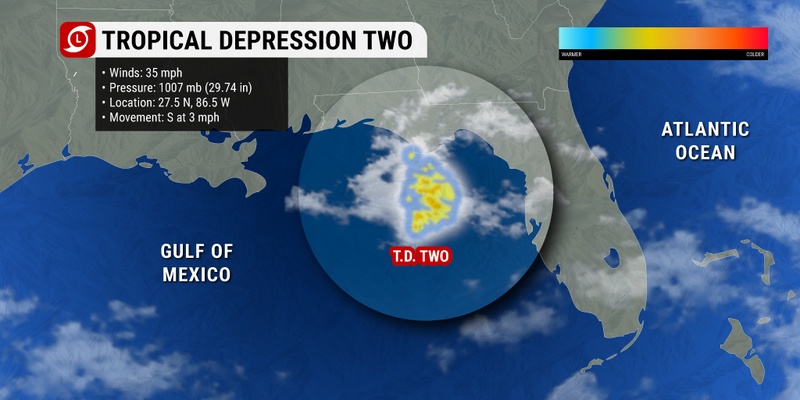
By Thursday morning, hurricane experts were becoming more certain that the storm would organize enough to become a tropical depression. It was only a few hours later that the system took on enough characteristics to be designated as Tropical Depression Two by the National Hurricane Center (NHC).
As of mid-morning Friday, Tropical Depression Two was spinning about 270 miles west of Fort Myers Beach, Florida, packing sustained winds of 35 mph. The feature was tracking in a southward direction at 5 mph. While the system is not going to make a direct strike on Florida, its impacts will be felt throughout the Sunshine State through at least Saturday.
This weather maker spun up less than a week after another storm system took root off the coast of the Carolinas, washing out the Memorial Day weekend for millions. Although this system took on subtropical characteristics, it made its way onshore and weakened before it had the chance to develop into a named storm.
Tropical Depression Two was able to find water temperatures in the low 80s. This warm water is a necessary ingredient for further tropical development. In addition, a low amount of wind shear present in this part of the Gulf has also supported its intensification over the last day or two.
Thursday’s initial satellite images demonstrated that the most powerful storms are located in the northeastern corner of the low-pressure center. This activity was enough to wrap around the defined center and become a tropical depression.
The NHC defines a tropical depression as an area of low pressure that pairs with robust thunderstorms moving around the center of the low.
Once the wind speeds reach a sustained speed of 39 mph, it will take on the designation of a tropical storm as defined by the NHC. Should this intensification occur, the storm will take on the name Arlene.
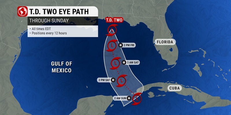
The NHC is predicting that a strong northerly wind will steer the system to the south into this weekend, sending the depression over the eastern and central portions of the Gulf of Mexico. These steering breezes will also work to keep the center of the feature off the coast of Florida, sparing the state the worst of the impacts.
However, this does not mean that Floridians will get off easy with this system. Thunderstorms will continue to roar up along the Gulf Coast portion of the state through the weekend. Those in the primary impact zone can expect a general 1 – 2 inches of rain.
Despite the potential disruptions for beachgoers this weekend, the state could use the rain in many places. According to Thursday’s data release from the U.S. Drought Monitor, the bulk of Florida is still under the designation of abnormally dry to moderate drought conditions.
The west-central part of Florida has been hit the hardest with severe drought conditions persisting.
Tropical Depression Two is taking an unusual path as it moves to the south. Storms of this nature typically move east to west during this time of the year.
The good news for those in its path is that the system will encounter more wind shear as it moves to the south, likely hindering its development in the coming days. The feature is unlikely to intensify into a named storm if it does not happen prior to late Saturday due to the wind shear in its path.
However, there is still the chance that the system could stay organized enough to drench western Cuba with torrential rain and strong winds by the end of this weekend. The primary impacts will be heavy rain and storms paired with high surf conditions for the western part of the island. There is also the chance of localized flooding.
Those in the Florida Keys will also want to keep an eye out on this development.
The NHC is also closely monitoring a cluster of clouds and thunderstorms located in the western Caribbean Sea and into the Bahamas and near Bermuda. A high amount of wind shear in place in this part of the Atlantic has kept this system from developing further.
This wind shear is predicted to stay in place in the coming days. However, a weakening of this wind shear could pave the way for future development.
Did you find this content useful? Feel free to bookmark or to post to your timeline for reference later.

January 21, 2024

January 19, 2024

January 18, 2024
